 |
| Kaavio Surtseyn muodostumisesta kuva wikimedia |
At 07:15 UTC on 14 November 1963, the cook of Ísleifur II, a trawler sailing off the Vestmannaeyjar archipelago south of Iceland, spotted something southwest of the boat, which turned out to be a rising column of dark smoke. The vessel went to investigate the smoke. The captain thought it might have been a boat on fire, but instead they encountered explosive eruptions giving off black columns of ash, indicating that a volcanic eruption had begun beneath the sea.
By 11:00 on 14 November 1963, the eruption column had reached several kilometres in height. At first the eruptions took place at three separate vents along a northeast by southwest trending fissure, but by the afternoon the separate eruption columns had merged into one along the erupting fissure. Over the next week, explosions were continuous, and after just a few days the new island, formed mainly of scoria, measured over 500 metres in length and had reached a height of 45 metres.
The new island was named after the fire jötunn Surtur from Norse mythology (Surts is the genitive case of Surtur, plus -ey, island). As the eruptions continued, they became concentrated at one vent along the fissure and began to build the island into a more circular shape. By 24 November, the island measured about 900 metres by 650 metres. The violent explosions caused by the meeting of lava and sea water meant that the island consisted of a loose pile of volcanic rock (scoria), which was eroded rapidly by North Atlantic storms during the winter. However, eruptions more than kept pace with wave erosion, and by February 1964, the island had a maximum diameter of over 1300 metres.
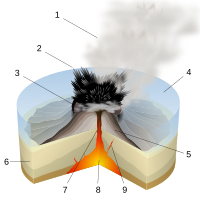
The explosive phreatomagmatic eruptions caused by the easy access of water to the erupting vents threw rocks up to a kilometre away from the island, and sent ash clouds as high as 10 km (6 mi) up into the atmosphere. The loose pile of unconsolidated tephra would quickly have been washed away had the supply of fresh magma dwindled, and large clouds of dust were often seen blowing away from the island during this stage of the eruption.
By early 1964, though, the continuing eruptions had built the island to such a size that sea water could no longer easily reach the vents, and the volcanic activity became much less explosive. Instead, lava fountains and flows became the main form of activity. These resulted in a hard cap of extremely erosion-resistant rock being laid down on top of much of the loose volcanic pile, which prevented the island from being washed away rapidly. Effusive eruptions continued until 1965, by which time the island had a surface area of 2.5 km2.
On 28 December 1963 submarine activity 2.5 km to the north-east of Surtsey caused the formation of a ridge 100 m high on the sea floor. This seamount was named Surtla, but never reached sea level. Eruptions at Surtla ended on 6 January 1964, and it has since been eroded from its minimum depth of 23 m to 47 m below sea level.
Lue koko artikkeli wikipediasta
 |
| Surtseyn saari Islannissa.
kartta wikimedia |
Ei kommentteja:
Lähetä kommentti